Download Autodesk AutoCAD Civil 3D 2025 (x64) for free, the full, permanent version. This civil engineering design and documentation software integrates the capabilities of CAD, BIM, and topographic data analysis. Installation instructions are included.
About Autodesk Civil 3D 2025
Autodesk AutoCAD Civil 3D 2025 This is a comprehensive civil engineering design and drafting program for creating all types of civil engineering drawings. It's an advanced version of the standard AutoCAD, an indispensable tool for surveying and design in the modern era, especially for projects involving extensive topographic data. The program can quickly import survey points or data from surveying instruments and create a 3D model of the original ground surface, allowing users to visualize the actual terrain before starting the design process. This differs from traditional 2D drawing methods that require imagining elevation changes.
One of the program's greatest strengths is calculating the volume of excavated and filled (cut & fill), a crucial aspect of project cost estimation. Civil 3D can analyze and show us exactly how much soil needs to be removed or how many cubic meters of fill soil are required for a given road level. It also displays color coding on the design to clearly show areas that are too high or too low, helping engineers make accurate design adjustments to save on construction costs.
Finally, there's the matter of design standards. The program has an automatic checking system to ensure that the road curves we draw or the pipe slopes we lay meet engineering safety standards. If any point doesn't meet the requirements, a warning mark will appear immediately. This helps to reassure designers that the work submitted is scientifically sound and feasible.
What's new in Autodesk Civil 3D 2025?
Autodesk Civil 3D 2025 focuses on improvements to infrastructure design performance, model management, and streamlined usability. Key features include:
1. Improve Surface Workflows.
- Making it easier to work with surfaces.
- Managing surface details is faster and more flexible than before.
- Performance: Surface creation is improved in both speed and stability.
2. Improve corridor workflows.
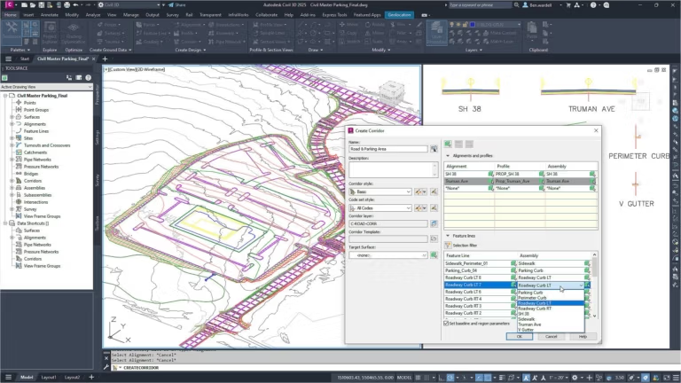
- Supports the creation of multi-baseline corridors, making it easy to configure multiple baselines in a single step.
- Features for creating and managing corridors allow for faster modeling of complex roads or runways.
- Performance: Creating corridor surfaces is many times faster.
3. New UI & Coordinate System Management.
- The UI for setting up the Coordinate System and Vertical Datum is clearer and faster.
- Supports a variety of coordinate systems, increasing positioning accuracy.
4. Esri ArcGIS Basemaps
- Expand access to various Esri Basemaps, such as street maps and satellite maps, to provide real-time spatial context during the design process.
5. Increased efficiency.
- Opening/saving files and regenerating models is faster compared to previous versions.
- MMS surface files only update when geodata changes, which reduces processing time.
6. Enhancements in Project Explorer & Dynamo
- Project Explorer improves data visualization and model management.
- Dynamo for Civil 3D was developed to improve automation.
- APIs and .NET 8 provide increased support to facilitate the extension of functions/custom workflows.
7. Minor improvements.
- Improve Profile Views, Rail workflows, and survey data collection procedures.
- Improved APIs and other miscellaneous enhancements for program stability and compatibility.
System Requirements
- Operating System: Windows 11 or Windows 10 (version 1809 or later), 64-bit only.
- Central Processing Unit (CPU): Minimum 2.5–2.9 GHz
- Recommended: 3.0 GHz or higher (Base) and 4.0 GHz or higher (Turbo).
- Note: ARM architecture CPUs are not supported.
- Memory (RAM): Minimum 8 GB
- Recommended: 32 GB
- Disk Space: 20 GB
- Graphics Processing Unit (GPU)
- Minimum requirements: 2 GB VRAM (Bandwidth 29 GB/s), DirectX 11 compatible.
- Recommended: 8 GB VRAM (Bandwidth 106 GB/s), DirectX 12 compatible.
- Screen resolution: Standard 1920 x 1080 (True Color)
- High-resolution display: Supports resolutions up to 3840 x 2160 (4K).
Additional recommendations If you need to work with point cloud files or highly complex 3D models, we recommend having at least 16 GB of RAM and a workstation-grade graphics card with at least 12 GB of VRAM for smooth operation.
File Information
- Operating System: Windows 11 / 10 (x64)
- Risk Level: Medium
- Developer: Autodesk
- Language: English
- Size: 8.7 GB
- File type: *rar
- Password: mawto
- Updated: 18/2/2026
- Required Reading: Download Guide
==== Main Download Link ====
==== Backup Link (Please help by downloading to prevent the link from breaking) ====